Written by meteorologist Lívia Caetano.
Storms are gaining strength again this Monday (15)
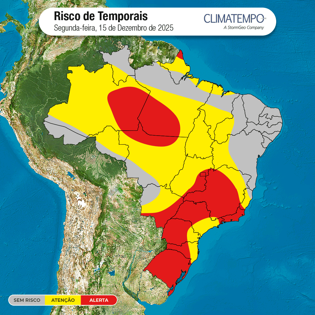
The last week of spring begins with unstable weather in much of the country , and storms are gaining strength again. This Monday (15) , the combination of the advance of a new cold front through southern Brazil, the action of a low pressure area and the excess of heat and humidity in the atmosphere favors the formation of heavy clouds, intense rain showers and storms in different regions.
Southern Brazil: Cold front brings heavy rain
In the south of the country, the cold front is advancing and causing rain in much of the region.
In Rio Grande do Sul, especially in the west and interior of the state, moderate to heavy rain is expected, with high volumes and a risk of storms.
In the western half of Santa Catarina and Paraná, as well as in northern Paraná, rain showers will also intensify throughout the day. In the eastern half of Santa Catarina and Paraná, however, the rain will be lighter.
Temperatures are decreasing in the southern half of Rio Grande do Sul, while heat still predominates in much of Santa Catarina and Paraná.
Southeast: Showers spread and intensify in the afternoon.
The weather has remained unstable since the beginning of the day in the Southeast.
Showers are affecting the southern half and west of São Paulo, as well as the northwest and eastern areas of Minas Gerais.
By late morning, unstable weather patterns will spread across the states of São Paulo, Minas Gerais, and Rio de Janeiro, intensifying throughout the afternoon. Rain will be moderate to heavy, with a risk of thunderstorms in several areas.
In Espírito Santo, it is raining in the south and interior of the state, while the north of Espírito Santo and the northwest of Minas Gerais continue to have drier weather.
Central-West: Heat and humidity maintain risk of storms
The presence of a low-pressure area over Paraguay reinforces the instability in the central region of the country, mainly in Mato Grosso do Sul.
By late morning, the rain will intensify in Mato Grosso and Goiás, increasing during the afternoon. Moderate to heavy showers are forecast for northwestern and southeastern Mato Grosso, much of Goiás, and Mato Grosso do Sul, with a risk of thunderstorms, especially in the southern part of Mato Grosso state.
Despite the rain, the heat continues to prevail in almost the entire region.
Northeast and North: more localized instabilities
In the Northeast, the weather will be more stable in most states. However, areas of Maranhão, western and inland Piauí, and western Bahia may experience moderate to heavy rain at times.
In the North, rain showers continue to occur in Amazonas, western and southern Pará, northern Rondônia, and much of Amapá, with moderate to heavy rain and a risk of isolated thunderstorms.
In Acre, Tocantins, and southern Roraima, rainfall is more moderate. In the interior, east, and northeast of Pará, precipitation is lighter. Temperatures remain high and the weather continues to be muggy.