Text written by meteorologists Gustavo Verardo and Vitor Takao
Warning for severe storms in São Paulo and Rio de Janeiro.
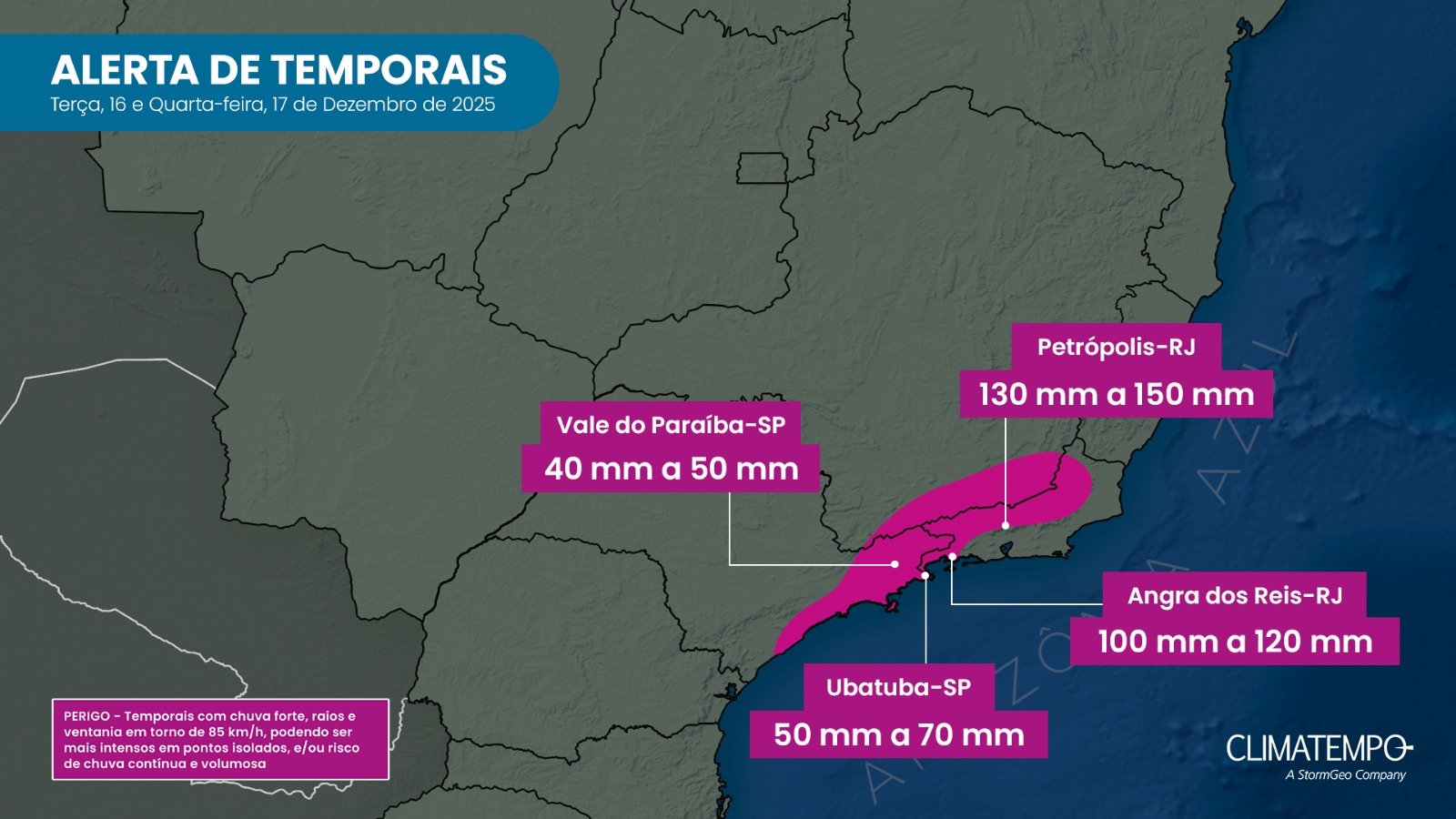
Starting this Tuesday (16) , the advance of a cold front along the Southeast coast will once again reinforce the instability and put São Paulo and Rio de Janeiro on alert for storms . The frontal system should cause significant rainfall , especially in the eastern part of São Paulo , with emphasis on the coast , where the high accumulated rainfall expected increases the risk of disruption .
Eastern region of São Paulo under alert for high volumes of rain.
In São Paulo, the rain will intensify throughout Tuesday and is expected to persist into the early hours of Wednesday. The situation is most concerning on the coast of São Paulo , in Greater São Paulo , and in areas of the eastern part of the state , where the combination of more persistent rain and high volumes could cause flooding , flash floods , and even sudden overflowing of streams .
In the interior of São Paulo state , showers also occur, some with moderate to heavy intensity , keeping these areas within the path of the storms, although with less persistence than on the coast.
On Wednesday (17) , the rain weakens in São Paulo, and the advance of a less intense polar air mass contributes to a drop in temperatures , more noticeable in the eastern strip and on the coast of São Paulo – but which should bring relief from the intense heat in the interior of the state.
Rio de Janeiro goes on alert between Tuesday night and Wednesday.
Between Tuesday night (16) and Wednesday (17), the cold front advances over Rio de Janeiro , intensifying instability throughout the state. There is a forecast of significant rain , with the potential for flooding and landslides , especially in the Serra region .
In the capital of Rio de Janeiro , volumes may be high, with potential for accumulations above 60 mm on Wednesday (17) alone , which increases the risk of disruption in urban areas.
The risk also extends to Minas Gerais.
In addition to São Paulo and Rio de Janeiro, the risk of storms and potential disruptions extends to areas in the south and Zona da Mata regions of Minas Gerais , where rain may occur with moderate to heavy intensity , accompanied by gusts of wind and lightning.
Other regions in the interior of Minas Gerais are also still under the influence of the instability, although with lower volumes compared to areas closer to the coast.
Given this scenario, Climatempo reinforces the need for heightened vigilance in areas under alert, especially on the coast of São Paulo, in the state of Rio de Janeiro, and in mountainous regions. The recommendation is to follow weather forecast updates regularly.